Vibe GIS-ing by WIZIPISI Vibe GIS-ing by WIZIPISI
Nowy paradygmat GIS w erze AI A new GIS paradigm in the AI era

GIS sterowany językiem naturalnym GIS powered by natural language

Koniec z przeklikiwaniem dziesiątek narzędzi. Opisz cel, a Vibe GIS-ing dostarczy analizy, mapy i raporty — agenci AI wykonają techniczną pracę za Ciebie.
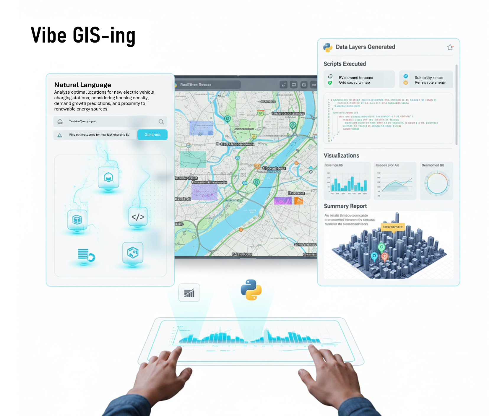
 No more clicking through dozens of tools. Describe your goal, and Vibe GIS-ing will deliver analyses, maps, and reports — AI agents do the technical work for you.

13+
lat doświadczeniayears of experience
~100
udanych projektów AIsuccessful AI projects
Wizualizacja działania Vibe GIS-ing

Język naturalnyNatural language

Zamiast nauki narzędzi — opisujesz cel po polsku lub angielsku.Instead of learning tools — you describe your goal in Polish or English.

Generowanie on‑lineOnline generation

Agenci AI tworzą skrypty, analizy, mapy i raporty w czasie rzeczywistym.AI agents create scripts, analyses, maps, and reports in real time.

Dostęp do sieciNetwork access

Monitoring, wyszukiwanie zbiorów i usług, integracje WMS/WFS/API.Monitoring, searching for datasets and services, WMS/WFS/API integrations.

Automatyczne daneAutomatic data

System sam wyszukuje i podłącza źródła najlepiej pasujące do potrzeb.The system automatically finds and connects sources best suited to your needs.

Mapy i raportyMaps and reports

Jedno wejście (NL), wiele wyjść: mapy, kod, raporty, wykresy.One input (NL), many outputs: maps, code, reports, charts.

Walidacja i audytValidation and audit

Widoczny kod i parametry, replikowalne kroki, kontrola jakości.Visible code and parameters, reproducible steps, quality control.

Czym jest Vibe GIS-ing?What is Vibe GIS-ing?

Vibe GIS-ing to styl budowy rozwiązań GIS wspierany przez AI. Użytkownik opisuje cel problemu w języku naturalnym, a agenci AI generują potrzebne zasoby: dane i warstwy, skrypty, konfiguracje, wizualizacje, analizy i raporty. Wynik jest weryfikowany i korygowany w kolejnych iteracjach rozmowy. Nacisk przesuwa się z obsługi narzędzi na rozwiązywanie problemów merytorycznych.Vibe GIS-ing is a style of building GIS solutions supported by AI. The user describes the problem goal in natural language, and AI agents generate the necessary resources: data and layers, scripts, configurations, visualizations, analyses, and reports. The result is verified and corrected in subsequent conversation iterations. The focus shifts from tool operation to solving substantive problems.

„Vibe GIS‑ing to styl budowy rozwiązań GIS wspierany przez sztuczną inteligencję.”“Vibe GIS‑ing is a style of building GIS solutions assisted by artificial intelligence.”
Źródło: A. Iwaniak, I. Kaczmarek, "Development of AI geo-agents ...", ICC, Vancouver, Canada, 2025Source: A. Iwaniak, I. Kaczmarek, "Development of AI geo-agents ...", ICC, Vancouver, Canada, 2025

Dlaczego to przełom?Why is it a breakthrough?

  • Szybko od intencji do wyniku — bez manualnego „klejenia” narzędzi.Quickly from intention to result — no manual “gluing” of tools.
  • Jeden interfejs (rozmowa), wiele wyjść (mapy, kod, raport).One interface (conversation), many outputs (maps, code, report).
  • Aktualne dane dzięki integracji z usługami on‑line.Up-to-date data thanks to integration with online services.
  • Walidacja i ślady audytu podnoszą jakość.Validation and audit trails improve quality.

Tradycyjny GIS vs Vibe GIS-ingTraditional GIS vs Vibe GIS-ing

Wymaga znajomości narzędziRequires knowledge of tools

Wystarczy opisać celJust describe the goal

Ręczne podłączanie warstwManual layer connection

Automatyczna integracja danychAutomatic data integration

Liniowy, czasochłonny workflowLinear, time-consuming workflow

Iteracje: dialog → wynik → korektaIterations: dialog → result → correction

Silosy narzędzi/formatówTool/format silos

Jedno wejście, wiele wyjśćOne input, many outputs

Ryzyko błędów operatoraRisk of operator errors

Walidacja przez agentówValidation by agents

Prototyp w akcji — „show, don’t tell”Prototype in action — “show, don’t tell”

Krótki pokaz: wpisujemy cel → powstaje kod → generujemy mapę i raport. Prototyp potwierdził potencjał podejścia — rozwijamy go dalej.A short demo: enter a goal → code is generated → we create a map and report. The prototype confirmed the potential of the approach — we are developing it further.

  • System rozumie cel w PL/EN.The system understands goals in PL/EN.
  • Agenci AI wyszukują dane i przygotowują skrypty.AI agents search for data and prepare scripts.
  • Powstaje mapa i raport — gotowe do przeglądu i korekty.A map and report are created — ready for review and correction.

Zobacz wideo z działania prototypu (30-60s)See a video of the prototype in action (30-60s)

Potencjalne zastosowania Potential applications

Vibe GIS-ing może zrewolucjonizować pracę w wielu branżach, przyspieszając analizy i podejmowanie decyzji. Vibe GIS-ing can revolutionize work in many industries, accelerating analysis and decision-making.

Smart City & Turystyka Smart City & Tourism

Prognozy pogody, wydarzenia i historia odwiedzin → alternatywy i trasy, krótsze kolejki, wyższa satysfakcja. Weather forecasts, events, and visit history → alternatives and routes, shorter queues, higher satisfaction.

Administracja i dane publiczne Administration and public data

Agenci wyszukują i integrują źródła; raporty zgodne z wymogami — szybciej i z mniejszym ryzykiem błędów. Agents search and integrate sources; reports compliant with requirements — faster and with less risk of errors.

Rolnictwo / Monitoring Agriculture / Monitoring

Dane satelitarne i meteo → mapy wskaźników i alerty — trafniejsze interwencje, oszczędności. Satellite and weather data → indicator maps and alerts — more accurate interventions, savings.

Środowisko Environment

Monitoring on‑line wskaźników, raporty trendów — szybsze wykrywanie problemów. Online indicator monitoring, trend reports — faster problem detection.

Logistyka / Planowanie Logistics / Planning

Dane popytu, ruchu i ograniczeń → warianty i oceny — niższe koszty i czasy. Demand, traffic, and constraint data → variants and assessments — lower costs and times.

Publikacja map/raportów Publishing maps/reports

Generowanie gotowych materiałów do komunikacji i decyzji. Generating ready-to-use materials for communication and decision-making.

WIZIPISI — zespół stojący za Vibe GIS-ing WIZIPISI — the team behind Vibe GIS-ing

13+ lat doświadczeń wdrożeniowych i ~100 projektów AI w GIS/EO. Specjalizujemy się w AI, GIS i integracji danych przestrzennych — przekładamy badania i prototypy na stabilne wdrożenia. 13+ years of implementation experience and ~100 AI projects in GIS/EO. We specialize in AI, GIS, and spatial data integration — turning research and prototypes into robust deployments.

Kastomizowane Sieci Neuronowe Custom Neural Networks
Analizy przestrzenne z AI Spatial analysis with AI
Agenci i orkiestracja Agents and orchestration
Automatyzacja raportów Report automation

Zaufali nam: Trusted by:

Logotypy partnerów WIZIPISI

"Współpraca z WIZIPISI pozwoliła nam zautomatyzować kluczowe procesy urzędowe oraz aktualizację danych, oszczędzając setki godzin pracy." "Cooperation with WIZIPISI allowed us to automate key office processes and data updates, saving hundreds of work hours."

— Dorota Michalik - Dyrektora Wydziału Geodezji UMK — Dorota Michalik - Director of the Department of Geodesy, UMK

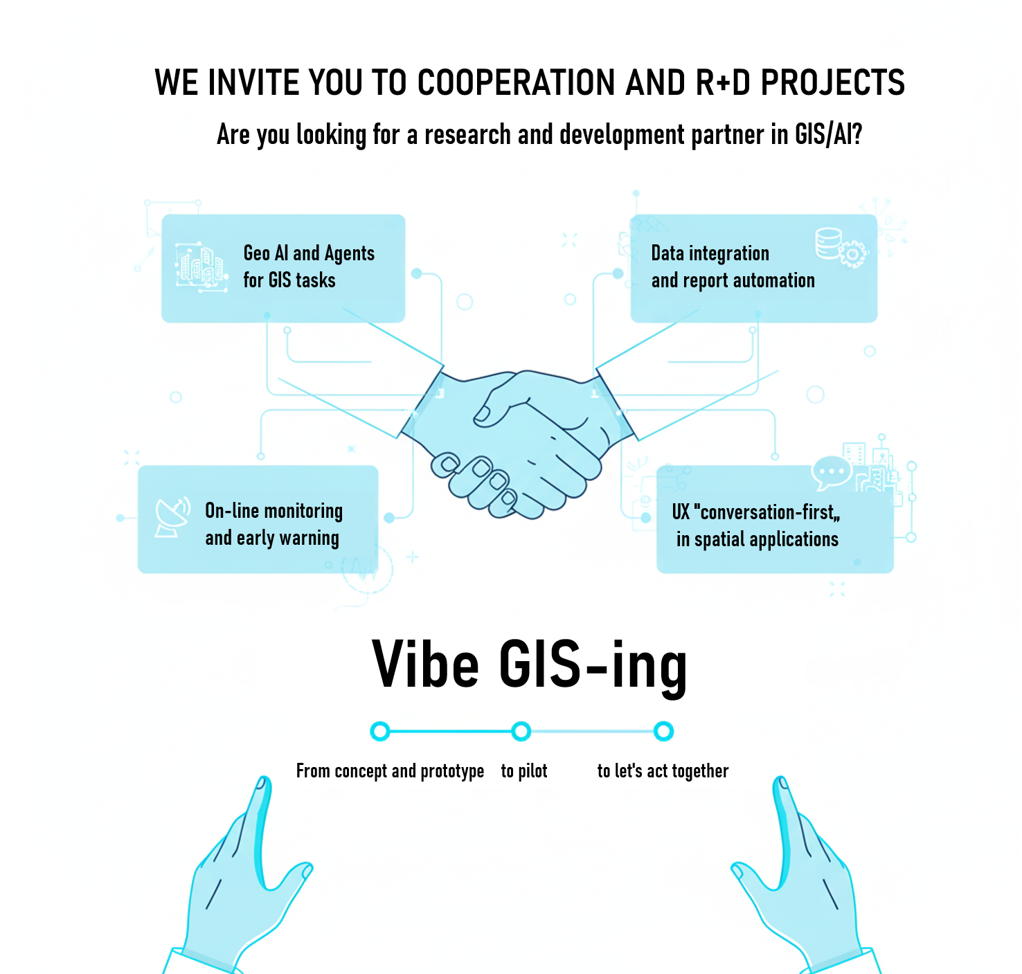
Zapraszamy do współpracy i projektów B+R We invite R&D collaboration

Szukasz partnera badawczo‑rozwojowego w GIS/AI? Od koncepcji i prototypu, przez pilotaż, do wdrożenia — działajmy razem. Looking for an R&D partner in GIS/AI? From concept and prototype, through pilot, to deployment — let's work together.

  • Geo AI i agenci do zadań GIS Geo AI and agents for GIS tasks
  • Integracje danych i automatyzacja raportów Data integration and report automation
  • Monitoring on‑line i wczesne ostrzeganie Online monitoring and early warning
  • UX „conversation‑first” w aplikacjach przestrzennych "Conversation-first" UX in spatial applications
Współpraca badawczo-rozwojowa

Skontaktuj się Contact us

Porozmawiajmy o Twoim przypadku użycia, demo lub wspólnym projekcie B+R. Let's talk about your use case, a demo, or a joint R&D project.